|
|
|
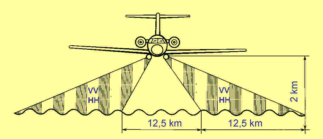
Ku-band (l=2.25
cm) real-aperture radar operating with the peak power of 60 kW, the
2 kHz pulse repetition frequency and a 110 ns transmitted pulse-width.
Two cylindrical
antennas, one on each side of the aircraft, transmit and receive alternate
pulses of horizontal and vertical polarizations at large incident angles
of 72-84 to produce simultaneous HH and VV images.
The radar swath
of 12.5 km is illuminated on each side of ground track. Spatial resolution
is about 25x25 meters.
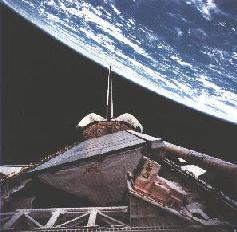
The Spaceborne Imaging Radar-C/X-band Synthetic Radar (SIR-C/X-SAR), carried in
the cargo bay of the Space Shuttle Endeavour in April and October of
1994, simultaneously recorded SAR data at three wavelengths
(L-, C-, and X-bands; 23.5, 5.8, and 3.1 cm, respectively). In addition,
the full polarimetric scattering matrix was obtained by the SIR-C
instrument at L- and C-band over a variety of terrain and vegetation
types. The integrated system is steerable in look angle (electronically
in the case of SIR-C, mechanically in the case of X-SAR) to obtain data in the angular range
of 15-16 Degree. Imaging resolution varies from about 10 to 50 meters,
depending on the geometry and data taking configuration.
Over the two flights, a total of 143 hours (93 terabits) of SAR data were digitally
recorded on tape for subsequent processing in the U.S., Germany, and
Italy. During the October 1994 flight of SIR-C/X-SAR, over one million
square kilometers of repeat-pass SAR interferometry data were also
obtained.
SIR-C/X-SAR is a cooperative experiment between the NASA (National
Aeronautics and Space Administration), the German space agency,
DARA (Deutsche Agentur fur Raumfahrtangelegenheiten), and the
Italian Space Agency, ASI (Agenzia Spaziale Italiana). SIR-C was
developed by NASA's JPL (Jet Propulsion Laboratory). X-SAR was
developed by the Dornier and Alenia Spazio companies, with the DLR
(Deutsche Forschungsanstalt fur Luft- und Raumfahrt), the major
partner in science, operations, and data processing.
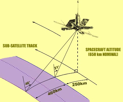
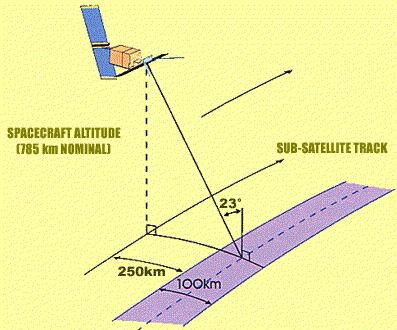
Ocean-7 was launched in October 1994. It was developed at the Institute of Radiophysics and Electronics of the Ukrainian Academy of Sciences. Spatial resolution is 1-3 km within a swath of 460 km. The incidence angle changes from 21° to 46° within the swath. The RAR operates at a wavelength of 3.16 cm with vertical polarization.
|
|
|